Jean-Marc DEOM
Laboratory of Geoarchaeology, Institute
of Geology, Min of Education ant Sciences KZ
GEO-ARCHAEOLOGICAL SURVEY OF ANCIENT METALLURGIC
CENTRES OF THE
1 - Location and
geography
The
Tertiary intrusive rocks (granite)
are exposed on the right side of the upper and middle parts of the Bazar-Dara valley. In the upper part (where the Ak-Jilga
mining village is located) they constitute the right slopes down to 4200 m; in
the middle part (where the Bazar-Dara town is
located) they are exposed 2-4 km up the mountain slopes at the height of 4500
m. They are composed of granodiorite breed with
crystal structure and interlocking mineral formations containing in relative
abundance wolfram, tin and other metals.
These mineral processes characterize a band 1
km wide and more of 20 km long that crosses the granite massive of the right
slopes of the middle and upper valley, making of the region a valuable source
of poli-metal ores.
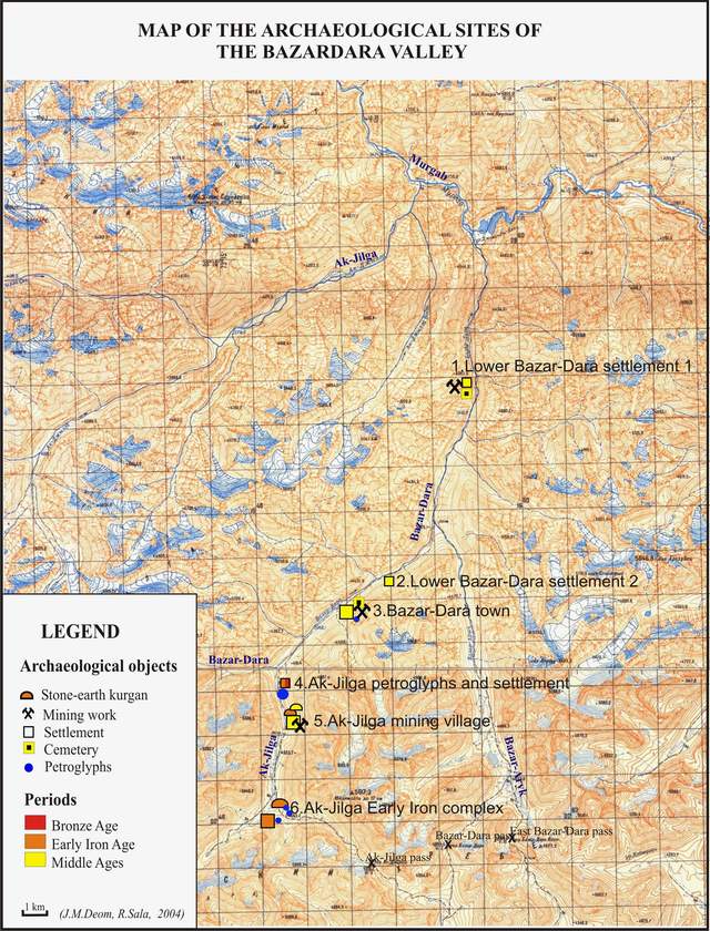
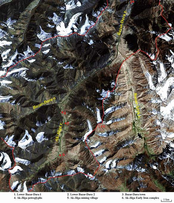
2 - Archaeological complex
The archaeological complex of the Bazar-Dara valley consists of 6 sites located along the
course of the AkJilga-BazarDara river.
From downstream to upstream, they consist of 2
small medieval (X-XI AD) mining villages (LowerBazarDara 1 in lower part of the valley and LowerBazarDara 2 in the middle part of the valley);
the large BazarDara medieval town in the middle part,
attributed to the same period; the AkJilga petroglyphs
at the junction between the upper and middle part of the valley, mainly
executed during the Bronze age; the AkJilga mining village,
1.5 km up from the petroglyphs site, with remains of the Medieval and
Ethnographic periods (X-XVIII AD); the AlJilga EarlyIron complex at the very upper end of the valley, in
a landscape of tundra-like cryophytic meadows, of which kurgans, housing and
few petroglyphs are attributed to the period (V BC-II AD)
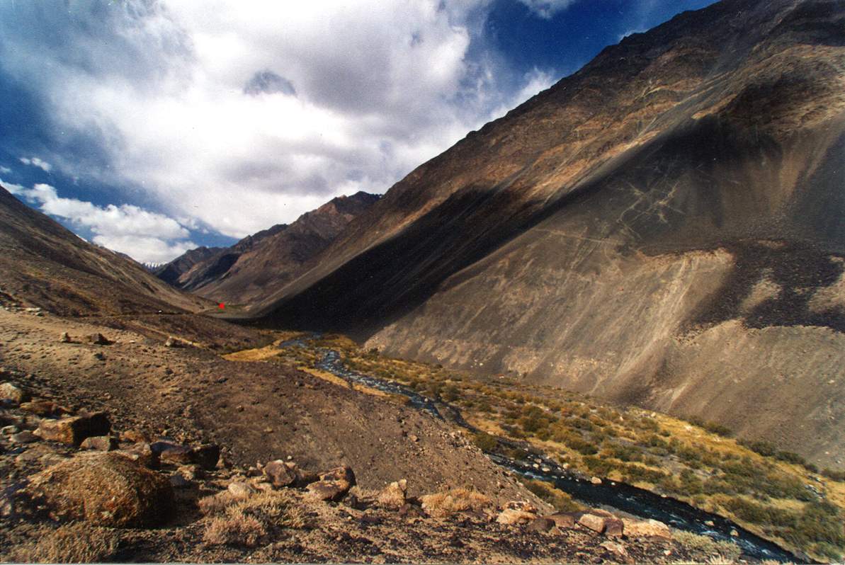
3 - Bazar-Dara medieval town
It is the most impressive monument of the
valley, if not for its antiquity, surely for its dimension most unusual at that
altitude. It is located in the middle part of the valley, on a large third
terrace of the right bank, at the height of 3980 m. The geomorphology of the
area consists of a valley with fluvial profile; the left bank is very steep and
covered by scree slopes; the right bank is characterized by a series of large
terraces. Its landscape is a high-mountain sagebrush desert with a narrow
corridor of tugai vegetation along the stream.
Archaeological monuments of several kinds are
found in the area: town, cemetery, mines and a few petroglyphs. The site has
been studied by extensive excavations (Bubnova
1962-64, 1972-75) and attributed to the Middle Medieval period (X-XI AD).
The town was mainly built for the organization
of the extraction and the transport-trade of the mineral resources of the
valley (copper, tin, silver). The ore was extracted and worked in a cluster of
mining and smelting villages located in the surroundings like Lower Bazar-Dara 1 and 2, Ak-Jilga mining village and eventually
other still undiscovered mining metallurgic sites.
The site of BazarDara
town covers an area of 700x250 m (17.5 ha). From the geomorphological point of
view the area consists of a hill and 3 terraces.
-
a south-western rocky hill
-
a main terrace (were most of the
buildings are located) developing SW-NE (like the valley) and descending from
60 m above the river bed on the SW to the level of the alluvial plain on the
NE. It covers an area of 510 x 220 m and is divided by a small canyon into 2
parts: the western one 210 m long is occupied by a caravanserai and living
quarters, the eastern one 300 m long is occupied by a cemetery.
-
a northwestern small terrace with
few traces of houses and mining activities
-
an upper terrace on the south of the
main terrace with only a few petroglyphs.
The distribution of the remains suggests the
division of the complex into 8 zones. Going from SW to NE they are the
following ones: the 1st zone (a rocky hill with petroglyphs and a
kind of panoramic post) constitutes the south-western borders; the 2nd
(caravanserai), 3rd (public building and square) and 4th
(living quarters) zones occupy the SW side of the main terrace; the 5th
(cemetery) and 6th (a few houses and bath) zones occupy the NE side
of the main terrace; the 7th zone (few houses and mines) is
peripheral and located on the north-eastern border of the complex; the 8th
zone (few petroglyphs) is located in an upper terrace hanging on the southern
slopes above the caravanserai.
Zones 2-3-4-5-6, located on the main terrace,
constitute the centre of the archaeological complex: they have been extensively
studied by archaeological excavations and their detailed description is given
in several articles by M.A. Bubnova (Bubnova 1979a, 1979b, 1980, 1984, 1985, 1990, 1996, 1997,
2001).
-
Zone 1. It consists of a rocky hill
located at the south-western border of the site containing cultural remains on
the bottom, medium and top levels of the hill. At the bottom, on the second
terrace of the alluvial plain, there is a stone enclosure (?) and on the first
rock outcrops a few petroglyphs of the Early Iron Age (goats) and an engraving
of the 1974 (a tent with some tools for archaeological excavations). On the
second level, a terrace 8 m up, there are 2 stones engraved with Early Iron Age
petroglyphs (goats) surrounded by small stone enclosures of ritual character.
On the top there is an artificial platform bordered by the remains of a square
stone construction.
Zone 2. Zone 2 is separated from Zone 1 by a small
valley 100 m wide hosting a seasonal stream and, at the bottom, a permanent
spring. It consists of the highest part of the main terrace (60 m above the
river bed) occupied by the remains of a walled compound of buildings covering
an area of 40x50 m2 (2 ha). The monument has been totally studied
through excavation and is classified as a caravanserai.
It has sub-rectangular shape with the entrance door opening in the centre of
the NE wall and driving to the main central street. A southern side-street
brings to 2 large courts for burden animals located along the SE wall. The
buildings are aligned on both sides of the main street and are constituted by
square and rectangular rooms provided with hearths and sofas and grouped by
functional blocks: on immediate right and the left of the entrance some small
custom houses; then a block with 3 storerooms of 50 m2 each and,
opposite it on the other side of the street, a large hall of 80 m2;
at the blind SE end of the street are located 2 blocks of living rooms, each
with around 15 rooms of 50 m2.
-
Zone 3. It is an area of ½ hectare
just outside the northern corner of the walled compound. It consists mainly of
an empty space occupied by the town square plus a large public building and a
few petroglyphs engraved on scattered bedrocks. The building (house 1) has been
studied by excavations: it covers an area of 200 m2 and has 8 rooms
of rectangular shape all provided with hearths and sofas. Near by some
engravings with figures of goats and dogs have been recently found (Sala, Deom 2004) on 2 outcrops with
patinated roundish surfaces and can be attributed to the same Medieval period
of the town.
-
Zone 4.
It is an area of 140 x 70 m (1 ha) located between the public square of Zone 3
on the SW and the little canyon crossing the terrace on the NE. It is a living
quarter occupied by around 80 houses partly studied by archaeological
excavations. The houses face with their entrance a central road that crosses
the settlement in the SW-NE direction. Each house averages 80-200 m2,
has 5-10 rectangular or square rooms provided with hearths and sofas and can
host 2-3 families. A few of them have been excavated (house 2-3-6-4). In House
2, located on the western border of the settlement, one of the rooms has been
recognized as a fire-worship temple. Some slag of fluorite and siderite
(remnants of smelting processes) have been found in a secondary deposits
outside houses 2 and 3; and slag of copper-oxide in a room of house 3 (Bubnova 1980, 1996)
-
Zone 5. It develops NE of the little
canyon along the sloping terrace 50 m wide and 220 m long (1 ha) and is
occupied by a cemetery with 484 tombs. The tombs consist of pits 1-1.5 m deep
covered by tumuli surrounded by low stone walls of square or oval shape. Six
tombs have been excavated (Bubnova 1964).
-
Zone 6. At the north-eastern end of the
sloping terrace is located a group of few rooms and, in proximity of the bottom
valley, a well preserved vaulted public bath with an under-floor heating
system. The bath has been studied by archaeological excavations.
-
Zone 7. On the following terrace, near the
ridge of the cliff, have been recently found (Sala, Deom 2004) the stone remains of 15 rooms and, 100-150 m up
the slopes, 2 quarry mines (surface trench) and one shaft mine (tunnel) 4 m
deep. The monuments have not been studied.
-
Zone 8. On the upper terrace south of the
caravanserai of Zone 2, a few petroglyphs have been recently found (Sala, Deom 2004) on flat
patinated roundish rock surfaces, that can be attributed to the Middle Medieval
period: pecked figures of goats in linear style and a bird, scratched figures
of a leopard and geometric signs (stars, squares). Further up along a small
path, at the height of 4400 m, some ancient mines have been discovered (Bubnova 1979a).
4 - Cultural Significance (Bazar-Dara
town)
Of the 6 sites constituting the archaeological
complex of the Bazar-Dara valley, 4 (LowerBazarDara 1 and 2, BazarDara
town and Ak-Jilga mining village) are definitely related to the mining and
smelting activities that exploited the rich ore deposits of the region. The
present attribution of these monuments to the Medieval period is mainly based
on the fact that Early Iron Age villages have been neither discovered nor
searched for. But the recent discovery of Early Iron surface ceramics in
Ak-Jilga petro village and Ak-Jilga mining village makes us suspect an earlier
date for the start of the mining works in the valley. Moreover, it is quite
probable that the scratched technique of the petroglyphs of the site of
Ak-Jilga petro is a characteristic of Bronze and Early Iron Age mining tribes;
and, referring to the newly discovered site of Ak-Jilga Early-Iron Age complex,
that future researchers will find witness of early mining activities even in
this part of the valley.
These considerations support the view that the
monumental heritage of the Bazar-Dara valley as a
whole represents an extraordinary testimony of the genesis and evolution,
during more than 3000 years, of the mining and smelting activities of Bronze,
Early Iron and medieval cultures, inserted in an astonishing high-mountain
scenario. We call it Bazar-Dara
valley paleo-mining complex.
The Bazar-Dara valley
can be classified as a natural-cultural property of
outstanding universal value (UNESCO-WHC code: 23-iii, 44a-i,ii,iii,iv).
Referring to the “BazarDara town” itself, its cultural significance consists
of it being the main monument of the mining and metallurgic activities of the
valley. Even if it was active during a short period of time (X-XI AD) and
understandable only in the context of the remains of the precedent and
successive mining and smelting activities which happened in the valley, its
size (17.5 ha) and complexity (caravanserai, living houses, bath, public square,
cemetery, petroglyphs) make it the most impressive settlement. It is by itself
a monument of outstanding universal value
following the UNESCO criteria (23-ii, 24a-ii,iv,v).
The surrounding cultural landscape,
for its evident functionality and intelligibility, can be classified as a cultural
relict (i.e. deprived of contemporary human use) organically evolved landscape
(39-ii).
5 - State of
The very dry climate of the region, the low
levels of erosion and the use of stones as building material are responsible
for the excellent state of conservation
of the monuments of the valley and of the Bazar-Dara
town in particular, even those exposed by archaeological works.
No human use of the area happened after the
abandonment of the Bazar-Dara town and also the
landscape comprising and surrounding the monument is preserved in its original
state. Therefore the monument is absolutely original and authentic
in all its aspects (24b-i) together with its surrounding cultural landscape.
Figures
01-BazarDara
valley / sites map
02-BazarDara
valley / sat image
03-BD
/ middle valley landscape
04-BD
mining town (X-XI AD) / plan
%20Plan.JPG)
%20Caravanserai%20Plan.JPG)
%20Caravanserai%20Photo.jpg)