VOLUNTEER CAMPS IN KAZAKHSTAN IN 2023
During the summer and autumn of 2023,
the Laboratory of Geoarchaeology (Historical Faculty, Al-Farabi Kazakh
National University) is organizing archaeological investigations covering all
periods from Iron Age to Modern times all over Kazakhstan. The work program
consists mainly in mapping, documenting and collecting paleodata for
analyses. Open-air lectures in the history, archaeology and paleoenvironment of
Central Asia are included. Sessions will take place between June and September
2023 and are 15 days in duration. Volunteers and students of archaeology are
welcome to join us. The participation fee is EU350 (or 380USD) per week and
academic credit is given by the Kazakh National University. Interested
volunteers and students of archaeology should contact the LGA to ask for full
details on the various survey and excavation opportunities on offer.
Renewed information is also available on the Laboratory of
Geoarchaeology web site: http://www.lgakz.org/VolunteerCamps/Volunteer.html
Or you can check the updated announcement of our volunteer
camps on the Fieldwork webpage of the Archaeological
Institute of America
There will be 5 expeditions occurring between
June and October 2023, the exact dates are not
firmly fixed and will be decided according to the grouping of volunteers at
fitting dates, they will occur in different regions of south Kazakhstan:
1- Lower Syr Darya valley, Kyzylorda region, upper Jana-Darya channel,
medieval oases of Kyshkala and Kumkala (8-15 centuries AD, study of
hydrological and archaeological remains), session
planned for 19 June-03 July 2023.
2- Middle
Syr Darya valley, Turkestan oasis, medieval town of Karachik (8-15 centuries AD, study of hydrological and
archaeological remains), session planned for 07-21 July.
3- Chu-Ili
mountains (Bronze Age to Modern times, petroglyphs documentation), session planned
for 30 July-13 August 2023.
4- Southeastern
Moyinkum desert, Zhambyl province (Holocene period, study of land and water
use, session planned for 17-31 August 2023.
5- Lower Syr Darya delta (upper
Kuvan Darya), Zhetyasar urban oasis (Geoarchaeological study), session planned
for 08-22 September 2023.
Application Deadline: Not applicable
HOLOCENE LAND AND WATER USE IN ARID ZONES OF KAZAKHSTAN
(SEMI-DESERTS, DESERT FOOTHILLS, DESERT DELTAS, SAND DESERTS)
|
Director: |
Renato Sala |
|
Site/Period: |
Bronze and Iron Ages, Turkic, Medieval, Modern
times |
|
Volunteers: |
5 |
|
Experience required: |
No previous experience necessary |
|
Excavation dates: Application deadline: |
5 sessions at the proposed dates of: 19 June-03 July, 07-21
July, 30 July-13 August, 17-31 August, 08-22 September 2023 ASAP |
|
Minimum stay: |
Two weeks |
|
Cost: |
EU350 / week |
|
Fare: |
Not included |
|
Accommodation: |
Provided |
|
Food: |
Provided (vegetarian and non-vegetarian) |
|
Vaccination: |
Anti-tetanus recommended |
|
Passport/visa: |
Valid passport; for visa contact organizer 4
weeks in advance. |
The geoarchaeological approach used
during our fieldwork documentation consists in the application of methods belonging to Quaternary
geology and environmental archaeology to which volunteers will be introduced
and trained. It consists in documenting natural landscape formation and its
historical evolution (geology, geomorphology, hydrology, stratigraphy, soils
and vegetation), in mapping cultural landscape through remote study and
fieldwork survey (archive material, cartographic and aerial photography, site
documentation, statistical and diagnostic analyses of surface findings and
monuments) and in gathering through archive material and live interview with
local population basic information about land and water use.
Archaeological trial trenches in
strategic locations and geological trenches for palynological analyses will be
implemented.
The weather is extremely dry.
Volunteers should bring a sleeping bag, a mat, a sweater, some strong shoes and
a flashlight.
|
Contact: Jean-Marc Deom, Laboratory of
Geoarchaeology (Faculty of History, Archeology and Ethnology,
Al-Farabi Kazakh National University), av.al-Farabi, 71, 4th Floor, room
4-8, 050040 Almaty, Kazakhstan |
||
|
Tel-GSM: +7 707 0485389 |
Fax: |
Email: ispkz@yahoo.com |
1- SEMI-DESERT
Chu-Ili mountains
The Chu-Ili
mountains are smooth rocky undulations of a maximum altitude 1500 m in a
semi-desertic landscape located between the southwestern Balkhash Lake and the
Tienshan range. Here springs and oases constituted a seasonal refuge, hunting
ground, mining site and a corridor for cultures from Palaeolithic to
ethnographic times, represented archaeologically by cemeteries, houses, steles
and, most predominantly, petroglyphs. From the Bronze Age to the Turkic periods
the area was a crossroads for tribal migrations reflected in the character and
range of petroglyphs, which now represent the most important monuments of the
area and are among the most important rock art sites of Central Asia and
Siberia.
Fieldwork
will be directed by specialists from the Laboratory of Geoarchaeology. During this survey, the camp will be nomadic.
You will work in various sites located in the southeastern border of the
Chu-Ili range surrounding the well-known sites of Kuljabasy and Tamgaly.
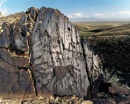
Kuljabasy mountains Bronze
Age petroglyph in valley 13
2- DESERT FOOTHILLS
Turkestan
oasis
The
Turkestan region represents an area of 110x80 km located between the Karatau
range and the Syr-Darya river. It includes 12 main river basins distributed on
average every 7-10 km along the 80 km width of the oasis, alternating wet
corridors with habitats for plants, animals and humans and intervalley deserts
in a steppe continental climate. It represents a cultural landscape typically
Central Asian similar to those found in the Nuratau, Ferghana, Zeravshan ranges
in Uzbekistan. Although densely populated by sedentary and semi-settled farmers
from ancient times, water deficit has long been expressed in all periods. Here
developed sophisticated irrigation systems including karez (groundwater
uplifting system).
In the
Turkestan oasis we will study the medieval town of Karachik (8-15th c. AD)
located along the richest river of the oasis (Bayaldyr) and investigate the
water supply and archaeological context of the site. The camp will be located
in a farmer house.
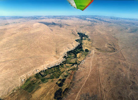
Aerial view to north of the village
Kumailykas in the Bestogai valley
3- DESERT DELTAS
Deltas are
very sensitive to natural and anthropogenic pressures so that their morphology
and hydrological regime is in constant change from flooding to desiccation.
According to water availability (climatic, hydrological and anthropogenic
conditions) and socio-economic trends, large portions of these deltas have
switched during historical times from phases of dense population to abandonment
and from periods of semi-settled to semi-nomadic agro-pastoralism.
For
evaluating the respective role of these factors, our research uses a threefold
approach based on paleoenvironmental, archaeological and ethnographical
analyses applied to the Syr-Darya delta where phases of occupation and
abandonment are historically documented.
a- Upper
Jana-Darya basin, Kyshkala and Kumkala
From the
start of the Holocene, river deltas in deserts have always constituted
privileged ecological niches for animals and men. Riverine forest and meadows
represent vital winter residence for both wild ungulates and domesticated
livestock and spring and summer floods offer to human communities the
possibility to practice irrigated agriculture. During summer, the deltas are partially
depopulated from their occupants moving to cooler places.
In
Kazakhstan, the earliest fortification structures arose in the Jana-Darya
(Chirik-Rabat culture 7th-3rd BC). This channel was later desiccated and
reactivated during the 8th century concordant with a Turkic Oghuz and to later
Khwarazmian, Kipchak, Karakalpak, Kazakh occupations (10-17th AD). Here we will
study the hydrological settings and the archaeological context of the upper
Jana-Darya between the oasis of Jend (Jankala, Kumkala) in the southwest and
Barchinkent (Kyshkala) in the northeast. The camp will be located in a farmer
house.
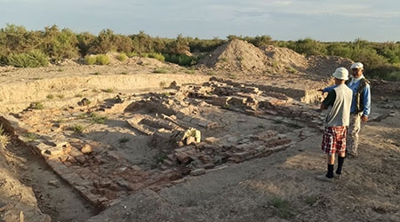
Excavations
of mausoleum 1 (Golden Horde period) in Kyshkala
b-
Eskidaryalyk basin- Jetyasar oasis
The Jetyasar
oasis is supposed to have been colonized by a population differing from the
former Chirik-rabat culture. Here, along the Eskidaryalyk channel, arose a
proper urbanized area based on residential castle-farms on platform surrounded
by fortified walls and with extended necropolises of kurgans and mausoleums in
their peripheries.
According
to the latest studies, the oasis would have been built by a mix of late
Sarmatians and proto-Hunnic tribes and would have constituted a hub of Alans,
Huns, Avars, Pechenegs towards their migration to the west. Here we will study
the hydrological settings and the archaeological context of the Eskidaryalyk
all along its course. The camp will be nomadic and situated in tents.
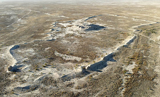
Aerial view to north of the castle Kuraily-asar
along the Eskidaryalyk
4- SAND DESERTS
The
Moyinkum desert
At the contrary of many sand deserts of South
Kazakhstan, the southeastern Moyinkum desert is rich in water sites which have
always attracted ancient herders as a seasonal rangeland. At the end of the
19th century, numerous stockbreeders of the lower Chu valley used the Moyinkum
as summer residence.
The greenest area of the southeastern Moyinkum is
represented by a band of lakes stretching between the Chu and Talas riverbeds.
A preliminary survey implemented in 2021 along this wet band has revealed
significant archaeological findings. This summer 2023, the fieldwork will be
devoted to a more detailed exploration of this area. The camp will be nomadic and
situated in tents.
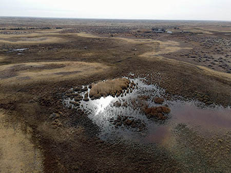
Aerial view to SW of Dolankuduk, a
farming site in the southeastern Moyinkum desert
Useful
reading
- R.Sala, Historical survey of
irrigation practices in west Central Asia (link: http://www.lgakz.org/Texts/LiveTexts/CAsiaIrrigTextEn.doc )
- Deom J.-M., 2022. The arid regions
of Daryalyk Takyr and Telikol: ethno-geoarchaeological study of a strategic
transhumance rangeland on the right bank of the Syr Darya delta, Kazakhstan. In: Studia Quaternaria, vol. 39, no. 2:
95-111. https://journals.pan.pl/Content/125118/PDF/3_Deom.pdf
- B. Andrianov (S. Mantellini,
Ed.) 2016. Ancient Irrigation Systems of the
Aral Sea Area. The History, Origin, and Development of Irrigated Agriculture.
Oxbow books.
- Tolstov S.P. 1962.
Po drevnim deltam Oksa i Yaksarta [Following the
ancient deltas of the Oxus and Yaxartes]. Moscow: izd.Vostochn.Literat.
- S. Robinson et al. 2017.
Pastoralists as Optimal Foragers? Reoccupation and Site Selection in the
Deserts of Post-Soviet Kazakhstan. Human Ecology 45: 5-21