|
Methods
- Research
Themes - Sites
- Projects
The work of the Laboratory of
Geoarchaeology is focused on the study of ancient human habitats and
encompasses a broad range of activities, from field survey and
aerial reconnaissance to field studies (geomorphology, geology,
paleoclimate, hydrology, pedology, palinology and botany, ecology,
archaeology), laboratory analyses, mapping and modeling, and the
publication of research.
A most important aspect of this work
is that no survey or study is solely site-based. Research objects
are large areas where archaeological remains are examined in the
context of the environmental surrounding so that an integral part of
the investigation is dedicated to the reconstruction of climatic and
environmental changes, settlement patterns, land-water use,
interregional roads, archaeological and modern landscape.
The Laboratory is currently involved
as an institution or through its members with several international
and interdisciplinary projects, funded through both local and
international institutions.
The section "Research Themes"
gives a broad picture of the main themes of research; the section
"Methods" underlines the basic procedures used by the
geoarchaeological approach; the section "Sites" lists the
areas and monuments of Central Asia where research has been applied;
the section "Projects" quotes the main projects that have
been implemented during the last 10 years.
top
METHODS
Fieldwork
Field work is
implemented by multidisciplinary teams and concerns research objects
not solely site-based but consisting of large areas where
archaeological remains are examined as part of the environmental
surrounding. Fieldwork, supported by preliminary existing
documentation, consists of visual study, trenches, collection of GPS
data for mapping, and the collection of samples for laboratory
analyses.
Remote sensing and aerial
photography
Remote sensing by satellite images and by
microlight aerial photography has been carried out for several sites
of Kazakhstan: the Turkestan oasis, the Otrar oasis, the Kyzylkum
dry deltas of the Syrdarya, the delta of the Talas river, Akyrtash,
Tamgaly, Serektas, and Issyk. [aerial
photography of the Laboratory of Geoarchaeology: pdf presentation
]
Laboratory
analyses
Laboratory analyses made in Almaty by members of the
Laboratory or in cooperation with colleague institutions cover most
of the exigencies of the geoarchaeological work: granulometry,
mineralogy (X-ray), elemental and organic chemistry, palinology
(pollen and spore), botany, microfossils and carpology, and ESR
dating.
Computer methods
Computer
methods (Excel, CorelDraw, MapInfo) are largely used for mapping.
Specific programs (Cropwat et alia) are used for simulative
modeling.
Protection and conservation
measures
Scientific documentation comprehensive of plans for
protection and conservation measures has been carried out, in
cooperation with UNESCO and with national agencies, for the
petroglyph site of Tamgaly and the mausoleum of Turkestan (nominated
in the World Heritage List), for the petroglyph sites of Eshkiolmes
and Arpauzen (inscribed in the World Heritage Tentative List), the
medieval oasis of Otrar, the Buddhist petroglyphs of Tamgalytas, and
the cultural landscape of the Eastern Pamirs.
Training
Training of young
specialists is a major concern among the activities of the
Laboratory.
Compilations are provided in English, Russian and
Kazakh languages for didactic purposes. They concern: geology,
climatic change, methods of the survey, study and protection of
cultural monuments, and surface and underground water uses in
Central Asia.
The section "Volunteer Camps" provides information
about the summer training camps for archaeological volunteers from
around the world, which the Laboratory runs every year.
top
RESEARCH
THEMES
Paleoclimate
Reconstruction
of paleoclimate and paleo-environment, based on palynological
analyses, has been provided for Semirechie during the last 3500
years; for the Lower Syrdarya region during the last 5000 years, for
the Taraz valley during the last 2500 years and in the Balkash lake
for the last 5000 years.
Land-water use
Chu-Ili
mountains (management of springs and wells from Bronze to
Ethnographic times); Otrar oasis on the lower Syrdarya (surface
water use by irrigation schemes from early to late Middle Ages);
Turkestan oasis (underground water systems "karez" of mid-late
Middle Ages)
Settlement
patterns
Settlement patterns of Bronze, Early Iron, Medieval
and Ethnographic times have been documented for Semirechie, the
Otrar oasis, the Turkestan Oasis, and the Eastern Pamirs. A database
of the urbanization of the Tienshan piedmonts and all Kazakhstan is
being completed.
Ancient metallurgy
Ancient
metallurgy has been studied: in the upper Bien valley where we have
studied through excavations 3 metallurgic villages (with more than
20 houses each and inhabited from Bronze to Medieval times) and
several kilns dated to Early Iron and medieval period; and in the
Turghen valley where 2 medieval kilns have been investigated. Aerial
and field documentation have been implemented in the Bronze Age tin
mines of the North Kalbinsk range (Askaraly).
Ancient and modern
landscape
Paleo and modern landscapes have been studied in
Semirechie, the lower Syrdarya, Karatau range (Kazakhstan) and the
Eastern Pamirs (Tajikistan).
Rock art
Central Asia holds
one of the richest and most abundant petroglyph collections on the
world, of which the study of the surrounding paleo-environmental has
been and is still mainly carried out by members of the Laboratory,
by geo-archaeological studies as well as by implementing, in
cooperation with NIPI PMK and with UNESCO support, a general data
base of Central Asia rock art sites and training of local
specialists for the standardization of methods (CARAD, Central Asia
Rock Art Database).
top
SITES
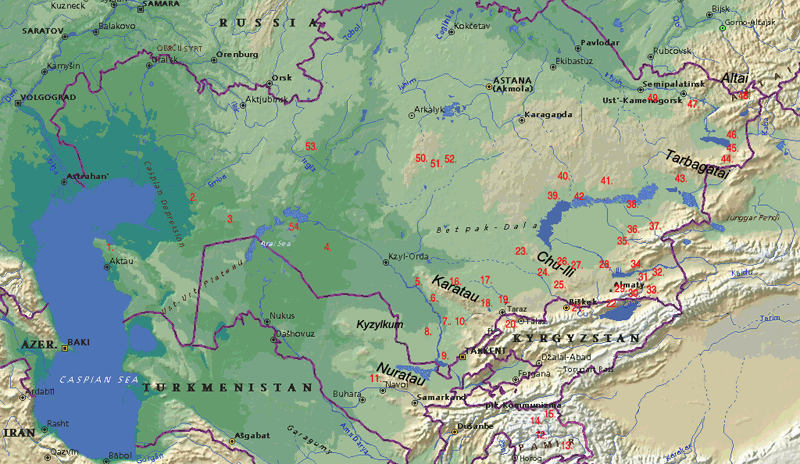
Map of the study-sites in
Central Asia (KZ, KG,UZ, TJ)
1-Shabgata (Paleolitic sites and
underground mosque); 2. South Emba (settlements and cemeteries); 3.
North Ustyurt (Mesolithic-ethnographic settlements, cemeteries and
animal traps); 4. Syrdarya delta (Kuandarya, Janadarya, Inkadarya;
Neolithic-ethnographic settlements and cemeteries, ancient
irrigation systems); 5-Signak(settlements and irrigation systems);
6-Turkestan oasis (settlements and karez systems); 7-Otrar
(settlements and irrigation systems); 8-Left Syrdarya bank-Kyzylkum
(settlements and irrigation systems); 9-Keles-Chardara region
(settlements); 10-Arys valley (settlements and irrigation systems);
11-Sarmishsai (Nuratau, petroglyphs); 12-Bazardara-AkJilga (mines,
settlements and petroglyphs); 13-Shakty (Mesolithic
petroglyphs); 14-Shoroly (settlements and petroglyphs);
15-Karakol (Iron Age cemeteries); 16-Arpauzen and Baba Ata
(settlements, mosque and petroglyphs); 17-Lower Talas valley
(settlements, cemeteries and irrigation systems); 18-Assa Valley
(Paleolithic sites, settlements and cemeteries); 19-Talas delta
(settlements and cemeteries); 20-Upper Talas (KG, settlements,
cemeteries and irrigation systems); 21-Chu valley (KZ and KG,
settlements, cemeteries and irrigation systems); 22-CholponAta
(petroglyphs); 23- Mount Jambul (settlements and petroglyphs);
24-Khantau (settlements and petroglyphs); 25-Kuljabasy (settlements
and petroglyphs), 26-Almaly (settlements, cemeteries, irrigation
systems and petroglyphs, 27-Tamgaly and Serektas (settlements and
petroglyphs); 27-Tamgalytas (settlements and petroglyphs),
29-Talgar valley and surroundings (settlements, mines and
cemeteries); 30-Turgen-Assy (settlements, mines, cemeteries and
petroglyphs); 31-Chilik (settlements, cemeteries and petroglyphs),
32-Charyn (settlements, mines, cemeteries, irrigation systems and
petroglyphs), 33-Kegen (settlements and cemeteries); 34-Besshatyr
(settlements, cemeteries and petroglyphs), 35-Eshkiolmes
(settlements, cemeteries and petroglyphs); 36-Bayanjurek
(settlements, mines, cemeteries and petroglyphs); 37-Upper Tentek
river (settlements and cemeteries); 38-Lepsy and Aksu deltas
(settlements, cemeteries, terraces and shorelines survey);
39-Torangylyk (settlements, cemeteries and shorelines survey); 41-
Sayak region (Stone Age workshops-campsites, settlements, cemeteries
and shorelines survey); 42-Tokrau valley-Uzynesyk peninsula (camp
sites, settlements, cemeteries, terraces and shorelines survey);
43-Urdjar (settlements and cemeteries); 44-Shilkty (cemeteries);
45-Zaisan-Shorga-Aksuat (settlements and cemeteries); 46-Kaljir
(settlements and cemeteries); 47-Ablaikit (settlements and
cemeteries); 48-Berel (settlements and cemeteries); 49-Askaraly (tin
mines, camp sites, settlements and cemeteries), 50-Ulytau
(settlements and cemeteries); 51-Karakengyr (settlements and
cemeteries); 52-Terekty (settlements, cemeteries and petroglyphs);
53-Khan Molasy (cemetery), 54-Peninsula Barsakelmes (settlements,
cemeteries and irrigation systems).
Balkhash-Tienshan
system
Paleoenvironmental evolution of the Balkhash Lake:
geology, climate, hydrology, botany and ecology. Study and GIS of
the ancient settlements and land-water use of the Ili-Balkhash basin
including the medieval settlements of the Chinese side have been
completed.
Lower Syrdarya
The lower
Syrdarya is one of the main study objects of the Laboratory. It
includes the oases of Chardara, Otrar, Turkestan, Chiili, the
ancient courses in the Kyzylkum desert (Zhosaly), the ancient delta
distributaries (Janadarya and Kyandarya), and the Kazakh shores of
the Aral sea.
Semirechie Bronze and Early Iron
Age habitats
Human habitats and paleo-environmental
conditions have been studied in sites of Semirechie located in 4
kinds of ecological environment: mountains (Turghen-Assy at
2500-3000 m asl, upper Bien valley at 1600 m); river canyons (Charyn
at 900 m); piedmonts (Talgar, Kegen at 800 m); and desert oases of
the Chu-Ili Mountains (Tamgaly, Serektas, Kuljabasy, Khantau at
500-800 m).
In the upper Bien valley and in Turgen the study
also concerned monuments of ancient metallurgy.
Petroglyph sites of South
Kazakhstan
Several rock art sites have been studied and
documented by geo-archaeological methods and some of them entered
into the standard database under the CARAD programme: Arpauzen
(Karatau), Khantau, Kuljabasy, Tamgaly (Chu-Ili mountains),
Tamgalytas (Lower Ili river), Eshkiolmes, Bayanzhurek, Tasbas
(Jungarian Range) in Kazakhstan; Sarmishsai in Uzbekistan (in
cooperation with the Institute of Archaeology of Samarqand); Shakty
and Ak-Jilga in the Eastern Pamirs, Tajikistan (in cooperation with
ACTED-UNESCO).
Otrar oasis
The upper layers
of some old towns of the Otrar oasis have been studied by
archaeological excavations during the last 40 years but the oasis as
a whole was never the subject of a systematic geoarchaeological
study. This has happened only during the last 4 years under a INTAS
project coordinated by members of the Laboratory. The work concerned
a large area of 80x40 km and produced: a reconstruction of the
paleoclimate and paleo-environment of the region for the last 5000
years; the paleo-hydrology of the Syrdarya and Arys rivers through a
study of abandoned courses in the central part of the oasis as well
as 80 km into the Kyzylkum desert; detailed fixation of
geomorphological features and reconstruction of 6 generations of
irrigation schemes correlated with settlement patterns and
estimation and modelling of paleo-water flow and agricultural
potential.
In cooperation with the UNESCO WH, 130 monuments of
the oasis (of which 40 were documented for the first time) have been
provided with a plan for protection measures.
Turkestan oasis
The Turkestan oasis has been the object of 2
investigations:
-
land survey, GPS mapping, satellite
images and aero documentation of all the medieval tobe (towns and
villages) of the oasis, in cooperation with the TAE (Turkestan
Archaeological Expedition) and the Turkestan Museum Azret
Sultan.
-
land survey with discovery, GPS
mapping and excavation, and aerial photo of systems of ground water
devices (karez) approximately dated to the Middle and late medieval
period, in cooperation with the TAE (Turkestan Archaeological
Expedition).
Chu valley medieval towns
(KG)
Aerial documentation of the medieval tobe and irrigation
systems of the Chu valley in Kyrgyzstan, in cooperation with
UNESCO-KG for documentation for protection and conservation plans.
Talas valley ancient settlements and land use
(KZ-KG)
The
upper course and the Talas valley in Kyrgyzstan and the middle and
lower course of the Talas river, as well as the valley of the river
Assa have been the object of geoarchaeological study (GIS,
paleoenvironmental reconstruction) during the years 2006-2008.
Iron
Age kurgan complexes of Semirechie and Northeastern
Kazakhstan
The
most impressive kurgan complexes of these two regions have been the
object of aerial photo-documentations and geoarchaeogical surveys,
they include the sites of: Burundai (Almaty), Issyk and Turgen,
Chilik delta (Zhuvan-tobe 1-2), Besshatyr, Aksuat, Shorga, Shilikty,
Berel.
Kalmyk fortifications and Buddhist
monuments
The
monuments of the Oirat (Jungar or Kalmyk) khanate in Kazakhstan are
the object of aerial photo-documentations and geoarchaeogical
surveys (mapping and paleoenvironmental reconstructions) as a
fundamental thematic study of the Kazakh Scientific Research
Institute on Problems of the Cultural Heritage of the Nomads. Among
the Oirat monuments researched are: Kalmaktobe (place of Anrakhai
battle, Eastern Chu-Ili Mountains), Zaisan forts (Kaljir and
Kurgan-tobe), Ablaikit, Jalauly (Kegen), Tamgalytas (Ili river).
top
PROJECTS
Several projects, from different sponsorship and in
cooperation with other national institutes (Institute of material
culture, ex-NIPI PMK, Thetys, etc), have been implemented under the
coordination or the participation of members of the Laboratory.
INTAS
- 97-2220: The formation
process of the nomadic societies in Semirechie during the Bronze and
Early Iron epochs. Ecological and archaeological investigations
(1998-2000).
- 2000-0699: Land use and
irrigation works in KZ in the present and historical times.
Geo-archaeological investigations. (2002-2005)
UNESCO:
- Land and aerial
survey and documentation of the cultural properties of Tamgaly,
Turkestan, Otrar (Kazakhstan), Sauran (Turkestan) for their
nomination in the UNESCO-WHL (2000-2009)
- CARAD, Central Asia Rock Art Database. Coordinator:
Alexey Rogozhinsky (2003-2006)
- ACTED-UNESCO (Project Cultural and Eco-tourism in the
Mountainous Regions of Central Asia and in the Himalaya): Land
survey and documentation of the monuments and cultural landscape of
Eastern Pamirs (Tajikistan) for protection and conservation measures
(2004) http://www.unesco.org/; http://www.natcom.unesco.kz/
OTHERS:
- OLKETANU
(Social Fund, Taraz): Geoarchaeological study of the Talas and Assa
valleys (KZ and KG) (2006-ongoing project)
- RIHN
(Research Institute for Humanity and Nature, Kyoto, Japan; Project
4-5FR Historical Interactions between the Multi-cultural
Societies and the Natural Environment in a Semi-arid Region in
Central Eurasia): Paleonvironmental
reconstruction and anthropogenic impacts in the Ili-Balkhash basin
(2008-ongoing project)
top |